Niagara Falls is considered one of the great natural wonders of the world, but it also serves as one of the top tourist destinations in Canada.
Nestled at the eastern edge of the Niagara region, the broader area is known for its thriving wine and tender fruit industries.
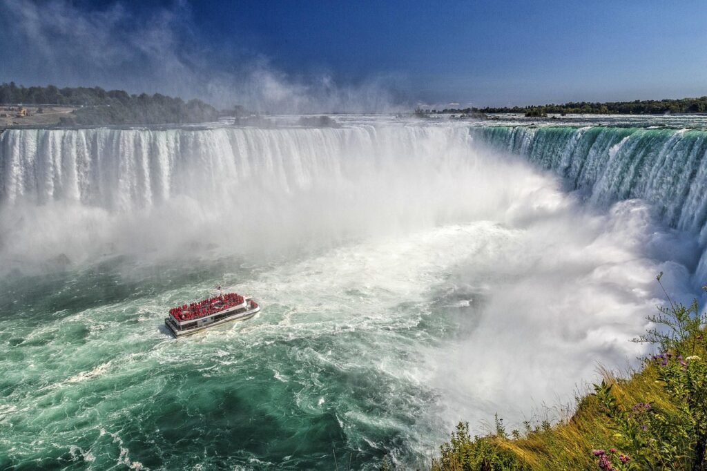
The Horseshoe Falls is located on the Canadian side of the Canada-United States border. As the name suggests, it forms a horseshoe shape and is often sought after for photos. The Horseshoe Falls is on the Niagara River and is beside Niagara River Parkway.
According to Niagara Parks officials, the Horseshoe Falls drops approximately 200 feet on average, the crest line (edge to edge where the water flows over) is around 2,200 feet, and the plunge pool (the basin at the bottom of the waterfall) is nearly 100 feet deep.
The American Falls is located beside Niagara Falls State Park in New York, but a direct frontal view can be seen from the Ontario side.
Officials said the drop at the American Falls ranges between 70 and 110 feet, and the crest line is approximately 850 feet.
There are dozens of things to see and do in Niagara Falls, including these notable destinations:
For a complete list of attractions as compiled by Niagara Falls Tourism, click here.
Located in the heart of downtown Niagara Falls, Ont., Clifton Hill is home to many and varied smaller attractions such as theatres, museums, haunted houses, mini golf courses and more. The Niagara Skywheel (a giant Ferris wheel) is one of the standouts in Clifton Hill.
To get to Niagara Falls, Ont., by car from the Greater Toronto and Hamilton Area, the Queen Elizabeth Way (QEW) and Highway 420 are the best ways. Depending on the time of day, it can take 1.5 to 2.5 hours to drive to the community from the heart of downtown Toronto.
Parking can be costly in certain locations near the popular downtown area and along the Niagara River. Click here for more on parking options.
GO Transit offers train and bus connections to Niagara Falls along its Lakeshore West corridor, which also serves Toronto, Mississauga, Oakville, Burlington, Hamilton, Grimsby and St. Catharines.
Flixbus, Megabus and Niagara Airbus all offer service to the city.
Trains to Niagara Falls from Toronto, Halton region, Buffalo, Rochester, Syracuse, Albany and New York City by Amtrak and Via Rail.
Once in the city, there are two public transportation systems: WeGo and Niagara Region Transit.
WeGo, operated by Niagara Parks, consists of three shuttle routes: Green line (north-south along Niagara Parkway beside the Niagara River, stopping at the GO Transit and Via Rail station), blue line (Niagara Parkway and the southern end of downtown), and Niagara-on-the-Lake. As of May 2026, 24-hour passes are $16 for adults and $12 for youth. For $4 more, you can get a 48-hour pass. GO Transit offers a combination fare that includes the cost of a WeGo pass.
Niagara Region Transit has several local routes that service the city and broader region.
Click here for more information on the Canada-U.S. bridge crossings.
The town of Niagara-on-the-Lake is located about 25 minutes north of Niagara Falls, Ont., where the Niagara River and Lake Ontario meet.
The municipality is home to more than three dozen wineries, including businesses that specialize in sought-after Icewine. The area is also home to a strong restaurant scene.
The community is home to the renowned Shaw Festival, which showcases in-demand theatrical productions.
If you want to learn more about the area’s history, head to the Fort George National Historic Site, the Fort Mississauga National Historic Site and other heritage destinations.